
 Posted by
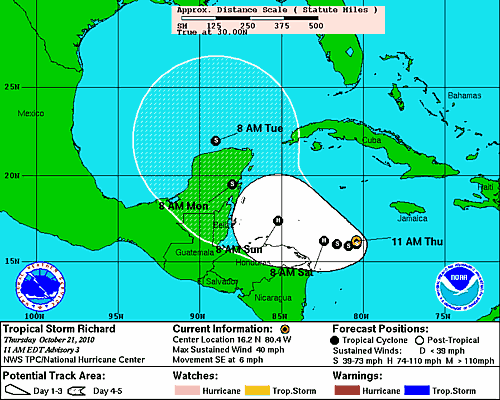
Projected Path of Tropical Storm Richard
The Current Location of Richard is 16.2°N 80.4°W, which puts it about 220 miles to the SSE of Grand Cayman. It is moving to the southeast at approximately 6 miles per hour. The National Hurricane Center’s projected path for Richard is one that will take it about 100 miles off the northern coast of Honduras by Sunday morning. From there the storm should make landfall somewhere along the Yucatan Peninsula, as likely a hurricane. Tropical Storm Richard will then likely emerge off the northern coast of the Yucatan sometime Tuesday morning. From there, computer models either take it towards the northern Gulf of Mexico, where shear weakens it significantly, or take it into the West Coast of Florida as a hurricane.
Computer models are just getting a handle on the situation, and will likely go back and forth in solutions over the next few days. All interests, especially along the western portions of Florida, should pay close attention to this storm over the next several days. It has the potential to be one of the most dangerous storms of the 2010 season for the United States. The hurricane season is winding down, however, that doesn’t mean that people along the coast of the Gulf and Southeast US can let their guards down yet.
