
 Posted by
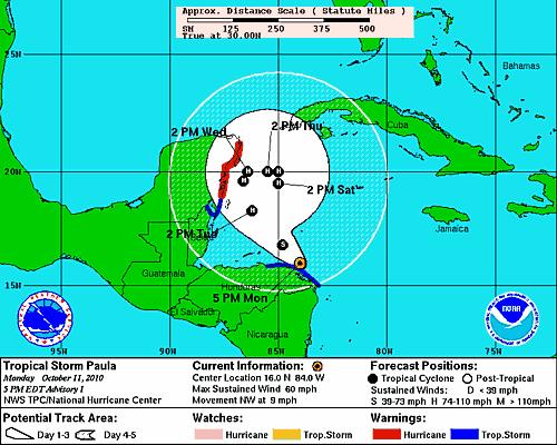
The Projected Path of Tropical Storm Paula
As we approach the latter part of the hurricane season, storms typically form in the Caribbean or Gulf of Mexico, and eventually move to the northeast. Paula, according to the 5 day forecast from the NHC, will likely meander in the Gulf of Honduras and Caribbean for the next several days. Paula is expected to strengthen, becoming a hurricane sometime in the next couple of days. The projected path of Tropical storm Paula takes it to the northwest, then north, placing it just off of Cozumel on Wednesday afternoon. From there it is projected to move east, and then south, putting it only about 250 miles to the NNE of where it is right now.
Hurricane warnings have been issued for the coast of Mexico from Punta Gruesa northward to Cancun. A tropical storm waring is also issued from Chetumal, Mexico, northward to Punta Gruesa. All interests along the eastern coast of Mexico, and later in the week, the Gulf of Mexico, should pay close attention to the future track projections.
