
 Posted by
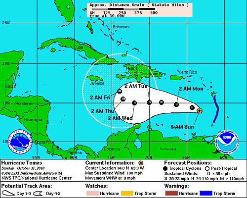
Projected Path of Hurricane Tomas
As of the 8AM AST National Hurricane Center advisory, Hurricane Tomas was located at 14.0°N 63.3°W, or approximately 155 to the west of St Lucia, and 355 miles to the SSE of San Juan, Puerto Rico. The storm is packing winds of up to 100 miles per hour, and is moving in a WNW direction at approximately 8 miles per hour. The projected path of Tomas is to continue it on a WNW path, and then on Thursday abruptly change to a more northerly heading. The National Hurricane Center has Tomas just south of the country of Haiti by Friday morning, as a very powerful storm.
Although we are still about 5 days away from any possibly landfall in the Caribbean, residents in the small country of Haiti, have to be on edge. A Major hurricane, the size of Hurricane Tomas, is something that, the country which experienced a major earthquake on January 12th of this year, which killed an estimated 230,000 people, doesn’t even want to consider.
Anyone in the Caribbean needs to pay extremely close attention to future National Hurricane Center updates.
