
 Posted by
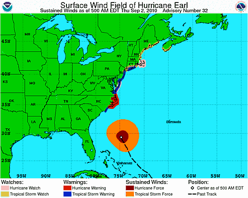
Watches and Warnings for Hurricane Earl
North Carolina
There is no doubt that many residents of North Carolina, especially the Outer Banks will experience intense hurricane force winds at some point tomorrow. By around 8Pm this evening, the North Carolina coast will start experiencing heavy rains and wind. By 1 Am tomorrow morning, the storm should be as close as it will get to the Outer Banks. Winds in excess of 90 miles per hour are possible for this area if the eye wall of Hurricane Earl makes it on shore. Things should begin dying down by around 11 AM on Friday.
Maryland and Delaware
The shores of Maryland and Delaware will certainly experience heavy rain and winds for extended periods of time. Tropical storm force winds are very likely, and hurricane force winds (74 MPH +) are a slight possibility. There will likely be coastal flooding, as well. A Tropical storm warning and Hurricane watch are in effect for these areas.
New Jersey
New Jersey, like Maryland and Delaware are further west than North Carolina, and Cape Cod, making them further from Hurricane Earl. By around 2PM Friday afternoon, Earl should be about 120 miles to the east of Atlantic City, New Jersey. The entire coast of New Jersey is under a Tropical storm warning, and will likely have tropical storm conditions throughout the day on Friday. Hurricane Force winds are a unlikely, but possible.
Cape Cod
Cape cod, is a geographical nightmare when storms come up from the South, since it juts out into the Atlantic. By around 2 AM Saturday morning Earl will likely be just offshore of Cape Cod. It will still be packing a punch as a category 2 Hurricane most likely. Cape Cod as well as Rhode Island, and the rest of the Massachusetts coast is under a Hurricane watch. This means Hurricane conditions are possible. Coastal Flooding and winds in excess of 70 miles per hour are likely in some locations.
